|
The planning team were requested to identify the optimal location to establish an industrial area for light and medium-scale industries in one of the districts.
Several criteria were defined that the proposed industrial site was to meet, including:
- The site should be close to an area where labour was readily available. The planers decided that the distance to a large residential area (e.g. one person) should be a criteria so that adequate supply of labour could be assured for the industrial area.
- Although the proximity to a residential area was viewed as being important criteria above, the proximity should be such that the proposed industrial area would not hinder the expected urban and residential expansion. The distance between the residential area and the industrial area also had to take into account that the noise and air and other pollution resulting from different industries would not negatively impact of the urban and residential area.
- Free and easy access to the main communication and transportation network should be foreseen. A link to a main road that has at least 12 meters breadth was defined as the minimum criteria.
- In order to ensure that the residential and urban areas were not affected by any possible air pollution that may result (despite efforts to ensure that such air pollution was avoided at source) the major wind directions had to be taken into account.
- The industrial areas requirements for basic services (e.g. water supply, sewerage treatment, electricity and telecommunications) had to be ensured. In order to keep costs to a minimum, the industrial area should be located as close as possible to existing services so that these can be easily connected rather than having to build new basic infrastructure lines.
- Areas that cause particular construction problems were also to be avoided. For example, locating the industrial site on or near a salt marsh was to be avoided, mainly due to the added construction costs that would be incurred when building in such a location. The industrial site was also not to be built on or close to any existing or planned agricultural area. This was necessary not only to avoid valuable agricultural land being converted to industrial use but also to ensure the agricultural land is not polluted or that it comes under pressure when the industrial site needs to physically expand.
|
|

|
In order to be able to select the optimal location using GIS the expectation is that a functioning GIS exists and that the relevant information is available. In the event that it is not available, the following requirements are needed:
Map data requirements: A cartographic map of the area to be analysed has to be available. In the example a cartographic map of the area that includes the town was available. The map contained the following information:
- The railway route, the railway stations, the irrigation canal as well as reclaimed areas;
- The main road network;
- The urban and residential areas as well as the administrative boundaries of the area, the towns and the city;
- Current agricultural land uses, grassland areas, areas containing palms and those denoting marches;
- Water pipelines, water network and existing wells;
- Wind direction
Hardware and software requirements: may differ and in view of the rapidly changing technology no specifications have been added with regard to minimum computing speeds or other very technical specifications:
- A personal computer
- Digitiser (Size: A3) or Scanner
- Plotter or Printer
- GIS Software (e.g. ArcView, AutoCAD)
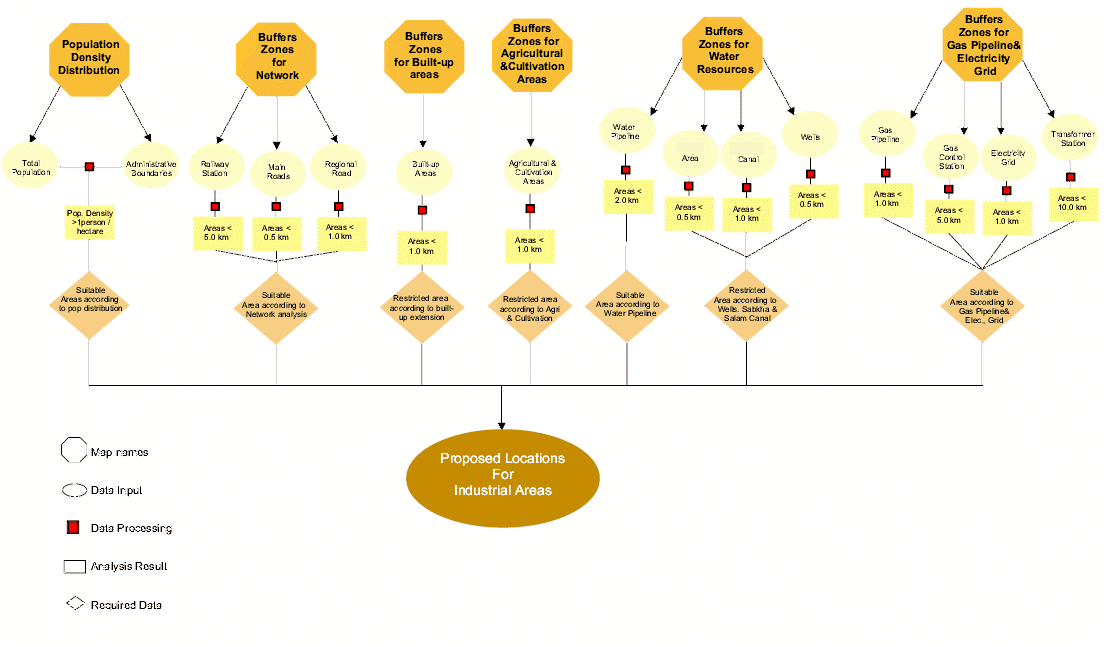
Steps undertaken for the site location in the city:
The process selected for the selection of the small industrial site in the city was based on the fact that a functioning GIS existed. The following main steps were undertaken:
- Data collection: All the necessary data required for use in the GIS was collected, including the topographic map and other socio-economic data. As data was not always available in the districts office, the data had to be procured from other agencies and organisations working in the area
- Data preparation: The analogue information (i.e. information on paper) then had to be prepared for eventual insertion into the computer (i.e. had to be digitised). The availability of the above mentioned hard and software had to be ensured. The data had to be prepared prior to entry into the computer, including:
- Selection of the X-Y coordinate system in order to allow for the identification of points of control that is needed by the GIS computer software
- Classification of the information into so called “layers”. This is needed in order to enter the information into the computer and in turn makes it easier to handle each piece of information as an individual picture.
- Selection of the most suitable colour combination for each layer of data and information to be presented on the map.
- Data insertion into the computer: The map had to be digitised into the computer according to the rules of the GIS and AutoCad system requirements. This process proved to be a resource consuming exercise and should not be underestimated in the workflow. Once all the data had been inserted it had to be checked for consistency and accuracy as far as the input was concerned.
- Data retrieval and editing: Once the maps have been digitised the fonts and the areas that will be selected for the analysis have to be edited, any descriptions needed on the maps have to be added and the colour composition of the maps have to be carefully matched.
- Data analysis: The buffer analysis approach was used to selectively define the areas of interest on the map. In other words, features on the map that were considered NOT to match a certain criteria were excluded from the map, the resulting map then only displayed the criteria that were of importance and relevance for the analysis. The following buffering exercises were undertaken:
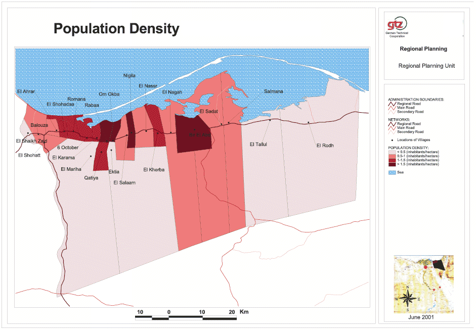
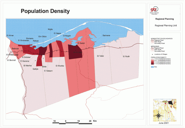
- Distribution of the population densities: The maps depicted the administrative boundaries, including the town that was being analysed. Both the current and the projected population figures were also added to the map. The overlaying information then revealed the spatial distribution of the population densities. By qualifying that areas only with a density of one person should be depicted, the buffering approach ensured that the map only depicted areas that fulfilled this criteria.
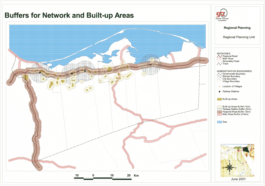
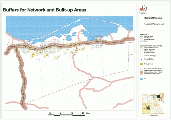
- Depiction of town’s main road network: As the road network had been inserted onto the digitised maps, the planning team could depict areas 1km width from the road network. In order to ensure that industrial sites do not spill over onto the road network a safety margin of 1km either side of the road had to be maintained. This was considered the minimum distance the industrial site should be located away from the main roads in order to allow for a buffer zone between the roads and the industrial site. In addition, a 5km area around the main railway station was also to be reserved and should be considered for selection as an industrial site. This would ensure that goods and services could easily be transported away from the industrial site.
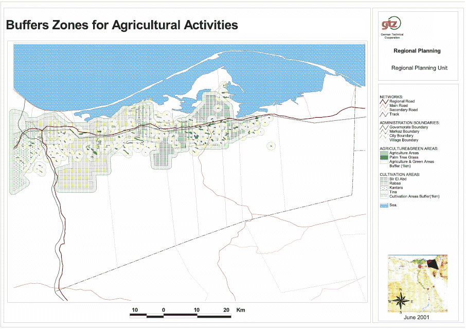
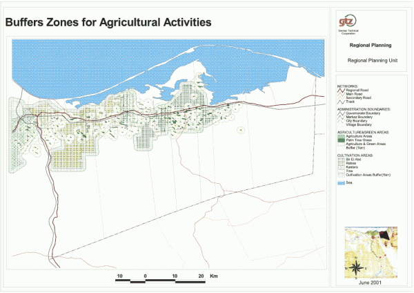
- Agricultural and area reclaimed: In view of the fact that the agricultural and reclaimed land is largely privately owned land, the planning team decided to ensure that this area would not form part of the industrial site. In addition to the fact that the land was private property, the planners also wanted to ensure that the residential areas would be not be affected by air pollution stemming from the industrial site. Therefore, a buffer of 1km was to be kept as far as agricultural land and areas that had been reclaimed.
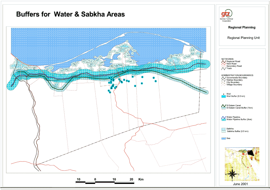
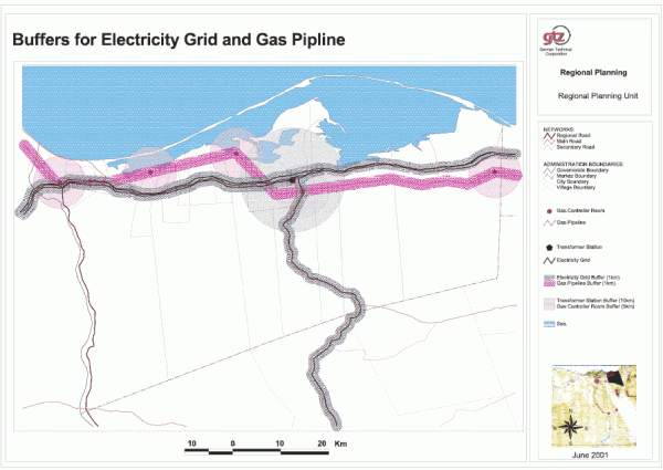
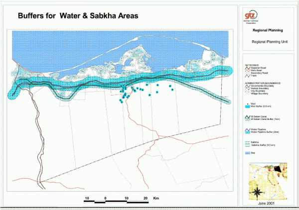
- Water pipelines, water wells, irrigation canal and salt marches: The industrial site requires considerable quantities of water and in view of the expense incurred in laying water supply pipelines, the planning team decided that the industrial site should be as close as possible to existing pipelines. The breadth of the area to be connected was defined to be 2km long. On the other hand water wells were to be protected so that they were not too close to the industrial site. Therefore, a 500m circumference around the wells was to be maintained. A safety belt along the irrigation of 1km was also to be maintained. This was thought necessary in order to ensure that the banks of the canal were not damaged or that the water is polluted through the industrial activity on the industrial site. Salt marches also present a particularly problem as far as construction matters are concerned. The costs of constructing industrial building on these salt marches pushes the costs up enormously as special foundations and other additional building measures have to be undertaken. Therefore, a buffer of 250m was to be kept to the salt marches.
- Identification of optimal site: Once all of the criteria (e.g. buffer areas) defined above had been entered into the GIS, the areas that fulfilled all of the conditions set was depicted by the computer. The main conditions that the area meets can be summarised as being areas that are:
- Close to relatively high population dense areas (e.g. 1 person);
- Close both to the main roads as well as the railway stations and water pipelines;
- Sufficiently far (i.e. safety margin to) from villages, specific urban communities, salt marches, wells and the irrigation canal;
- Outside the range of land used for agricultural purposes and land that has been reclaimed.
The final maps clearly shows that by defining specific criteria that have to be met or factors that have to be excluded during the choice of a suitable area, the optimal sites that fulfil all of the criteria can be quickly and easily depicted using the GIS system. A final factor that was introduced in the selection process for the city was the wind direction as this had an influence on the direction that any possible air pollution would take towards the residential and urban areas.
|
 |
Map 2: Buffer Zones for Agricultural Acitivities in Markaz Bir El Abd
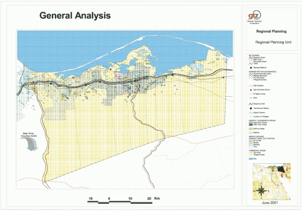
Map 3: General Analysis in Markaz Bir El Abd
Map 4: Buffers for Electricity Grid and Gas Pipeline in Markaz Bir El Abd
Map 5: Buffers for networks and build-up areas in Markaz Bir El Abd
Map 6: Population Density in Markaz Bir El Abd
Map 7: Buffers for Water and Sabkha Areas in in Markaz Bir El Abd
|