Delineation of Rural Hinterland - Brief Description
|
|
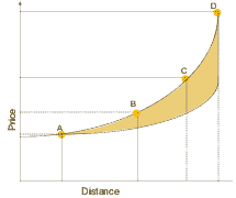
A district is not only a system of functionally diversified settlements but also a network of social and economic and physical interactions. The processes and interactions are shaped by roads among settlements and villages in- and outside the district. Roads allow people living in an area to obtain access to the economic activities, infrastructure and social and administrative facilities. The road network determines the access of the urban traders and entrepreneurs to rural resources and raw materials. Within this system of interdependent interactions, the urban sector may become dominant to the disadvantage of the rural sector. Within settlement patterns prices may differ. In general, prices increase with increasing rank of an urban place within the settlement hierarchy. As transportation costs do not explain the whole price difference the income situation of villagers can be improved through better rural-urban linkages, access to information on market prices etc. There are a number of methods that help to study rural-urban linkages. They range from time budgets to market and transportation studies and from trading to social interaction and migration studies. The degree of functional integration can be measured in the following way:
Figure 1: Market price development within a settlement system
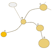
The shaded area indicates the difference between transportation costs and the market prices per unit. A, B, C, D indicate the rank. A denotes a village, B district centre, C & D provincial centres Figure 2: Spatial product path
|

