Digital Tax Parcel Mapping - Example: iTax Mapping in the Philippines

files/images_static/practitioner.jpg

Background

In the Philippines tax mapping is a more than twenty year old standardized procedure to assist the real property tax assessors in a comprehensive and homogenous field based valuation of all taxable land parcels in a municipality. It serves as a basis for a just and uniform taxation of real properties. Previously real property taxation was solely based on self declaration by property owners or claimants.

Current workflows and procedures of the Philippine real property administration system were established in the 1980s and 90s. During this time, substantial efforts to introduce an effective local real property valuation and taxation system were undertaken with financial and technical support from US Aid and the Worldbank. A significant innovation was the establishment of the present map based parcel identification and location system as well as standardized procedures of tax mapping.

In the Philippines the objectives tax mapping operations are defined as follows (Department of Finance, DoF, 1978):

  • To establish a complete inventory of all real property;
  • To provide a permanent link between real property and office records;
  • To identify the ownership of every piece of real property;
  • To account for the sum total of all land areas of provinces or cities


Part of the tax mapping operation is the production of tax maps. Key elements of Tax Maps include:

  • A graphic representations of a portion of the earth’s surface drawn to scale on standard size drawing material;
  • Having property lines and jurisdictional boundaries delineated showing all parcels of real property and identifying each separate real property ownership by a unique number;
  • Being constructed from a base map normally based on cadastral maps;
  • That each parcel in the tax map is being identified by a property index number (PIN) reflecting the city/municipality, district, barangay, and section of its location.

In February 2007, the GTZ Decentralization Programme in cooperation with the provincial government of Negros Oriental developed an Integrated Taxation Management System (iTAX) based on an intensive analysis of local needs and requirements, and focusing on real property tax.

iTAX is a modern computer-based assessment and collection tool for use by the local governments. It is a computerized computing and accounting system for local revenue (levies, taxes) which stores all relevant (credit/debit) data of the project in individual accounts and a relational data bank and thus helps to monitor/control all tax transactions of its citizens and tax payers.

Originally, this system was first developed by GTZ together with the national fiscal administration of Tanzania (TRA). The iTAX software was adjusted and modified to suit the requirements of the Philippine local tax administration. iTAX is based on PowerBuilder as a development tool and relies on the Open Source database INGRES. The current version used in the Philippines has been further developed with the focus on local levies and taxes as well as the component “digital tax parcel mapping” (graphical presentation of tax relevant data).

An important component of the whole iTAX system is the integration of the tax mapping process into the application. A major expected benefit is that tax authorities as well as the tax paying public get a much better graphical overview of the overall tax situation of the municipality through thematic tax maps.

The primary objective of the iTAX digital mapping component was to produce a municipal wide “stand alone” digital tax parcel mapping system to be used by the municipal and provincial assessors to replace their traditional paper based tax maps. To achieve this a decision was taken to opt for a simple and straightforward solution for the digital conversion of the existing tax parcel maps.
However, it is possible for the individual local governments to update and improve the geographic accuracy of their digital parcel layer and to build a true multi-purpose municipal digital base map at a later stage.

The manually drawn compulsory tax maps maintained in the assessor’s office include:
(1) Municipal Index Map;
(2) Barangay Index Map;
(3) Section Index Map; and finally and most importantly the
(4) Property Identification Map.

The latter one shows the lot boundary with its corresponding lot or property identification number which in turn corresponds with the section index map of the barangay.

Digital Conversion of Hard Copy Tax Parcel Maps

Two options were used by the iTAX project in generating the municipal digital tax parcel maps:

  1. Digitizing and Georeferencing of the existing paper maps using a GIS software.
  2. Encoding the field surveyed parcel measurements (Lot Data Computation - LDC) or technical descriptions which were secured from the regional cadastral office, the Bureau of Lands of the Department of Environment and Natural Resources  (DENR) and converting the parcel survey data such as coordinates, bearings, distances or the road geometry into point coordinates through a COGO (Coordinate Geometry) programme or script.


Using the first option of the process of converting the existing paper tax maps of the assessor’s office into a digital format consists of the following working steps:

  • Digital map conversion:
  1. Scanning or photo capturing of the Barangay Index Map (Basemap), Section Index Maps and the Property Identification Maps.
  2. Image Processing
  3. Image Georeferencing (Image Warp)
  4. Digitizing of Parcels/lots and Attribution of Property Identification Numbers (PINs)
  • Database Synchronisation
  1. Linking the digital parcel map into the iTAX application by embedding them as an ActiveX component in the application
  2. Creating Thematic Maps such as Land Use, Payment Status, Type of Ownership, Assessed Value, Market Value, Tax Delinquents and others
files/images_static/bulp.jpg

Key Steps


Step 1: Digital Conversion of Assessor’s Barangay Index Map, Section Index Map and Property Identification Maps (PIM)


As a low cost alternative to using a large scanner to reproduce digital copies of all paper maps at the assessor’s office, the use of a digital camera has proven to be an efficient and effective method. The recommendation is to use a good quality digital single lens reflex camera mounted on a tripod. It is very important, not only that an exact parallel camera angle is ensured but also that the paper maps are flat and smooth. The maps can be pasted on a wide wall, this helps to avoid camera tilt which in turn may cause image distortions.


Fig. 1    Example of a Property Identification Map

Fig. 2     Example of a Property Identification Map

Step 2: Image Processing

Image mosaic/stitching of maps using Photoshop
During this process all digital images of the property identification maps that have been either photographed or scanned are assembled, merged and “photo-stitched” together to convert them into single section index map. With the help of image processing software such as ADOBE Photoshop all section index maps are then digitally merged into a barangay map


Fig. 3    Individual section index maps assembled / merged to Barangay parcel map


Step 3: Image Geo-referencing (Image Warping)

The next major step in the process of creating the digital tax maps is the so called Geo-referencing (also called geo-coding). This is a process through which a set of data is assigned geographic coordinates, which in turn links them to known geographic locations on a topographic map. Geo-referencing involves defining a location in physical space by establishing a relation between raster or vector images to known map projections or coordinate systems. To geo-reference an image, one first needs to establish control points, input the known geographic coordinates of these control points, choose the co-ordinate system and other projection parameters and then minimize residuals. Residuals are the difference between the actual co-ordinates of the control points and the co-ordinates predicted by the geographic model created using the control points. They provide a method of determining the level of accuracy of the geo-referencing process.

Fig. 4    Barangay Parcel Map before assigning geographical control points


Fig. 5     After assigning of geographic control points, the image is projected to the appropriate location of the base-map


Step 4: Digitizing of parcels/lots and attribution of Property Identification Numbers (PINs)


This step involves either online or screen digitizing of all parcel boundaries and establishing a link between each individual lot to the data attribute table in the GIS database through the unique Property Identification Number (PIN). This is the most time consuming working step. The PIN number is the all-important unique parcel identifier which allows linking of any given parcel to its exact administrative location within the Philippines. 

Example for Municipality PIN: 046-20-001-01-001
        046    -    Provincial Code
        20      -    Municipal Code
        001    -    Barangay Code
        01      -    Section Code
        001    -    Property / Parcel number
 

Fig. 6     Each digitized parcel is given a unique property identification code (PIN)


files/images_static/finger.jpg

Second Method of Digital Conversion of Hard Copy Maps

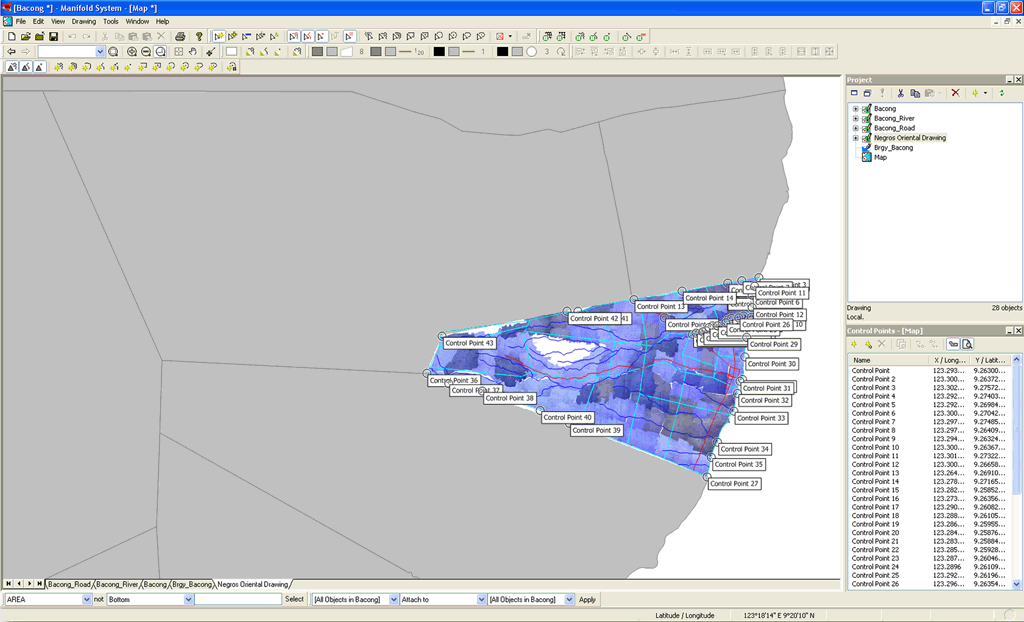
This method is an alternative approach applied by the iTAX team to convert the hard copy parcel maps into a digital format. The method reduces the effort and time needed to create digital parcel maps because all the parcels are automatically drawn and there is then no need for geo-referencing and digitizing. An important advantage of this approach is that it creates the exact position, area and shape of the lot as surveyed in the field by the geodetic engineer.

The limitation of this approach is that it is time consuming to encode the technical descriptions. Furthermore, in most cases the data is not available in digital form. When numerical errors of the given coordinates exist, they have to be corrected and computed again by a geodetic engineer. It was also found that some figures are difficult to read because of old, crumpled or torn survey documents. Often there is also no updated subdivision data, depending when the cadastral survey was undertaken. Finally, the method also requires permission to be granted by the Bureau of Lands to photocopy the original records at the regional cadastral office.


The individual steps applied are:

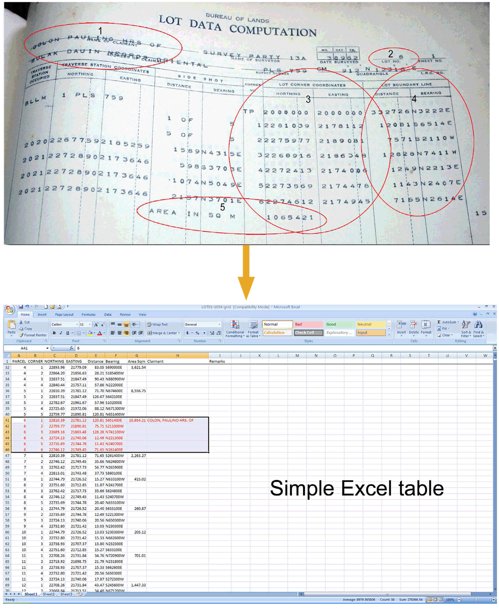
  1. Encoding of technical description of cadastral lots using the Northing and Easting Coordinates in a MS Excel file.
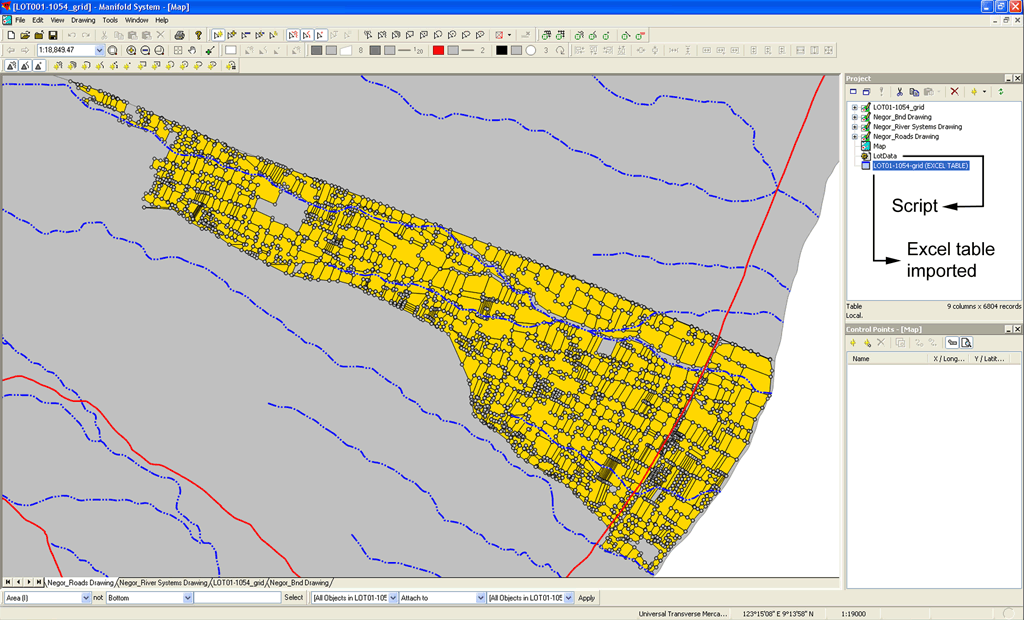
  2. Importing the Excel table into the GIS software and running the COGO script that will then plot the parcels automatically.
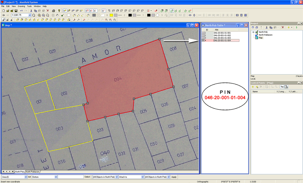
  3. Adding the Property Identification Number to each parcel.


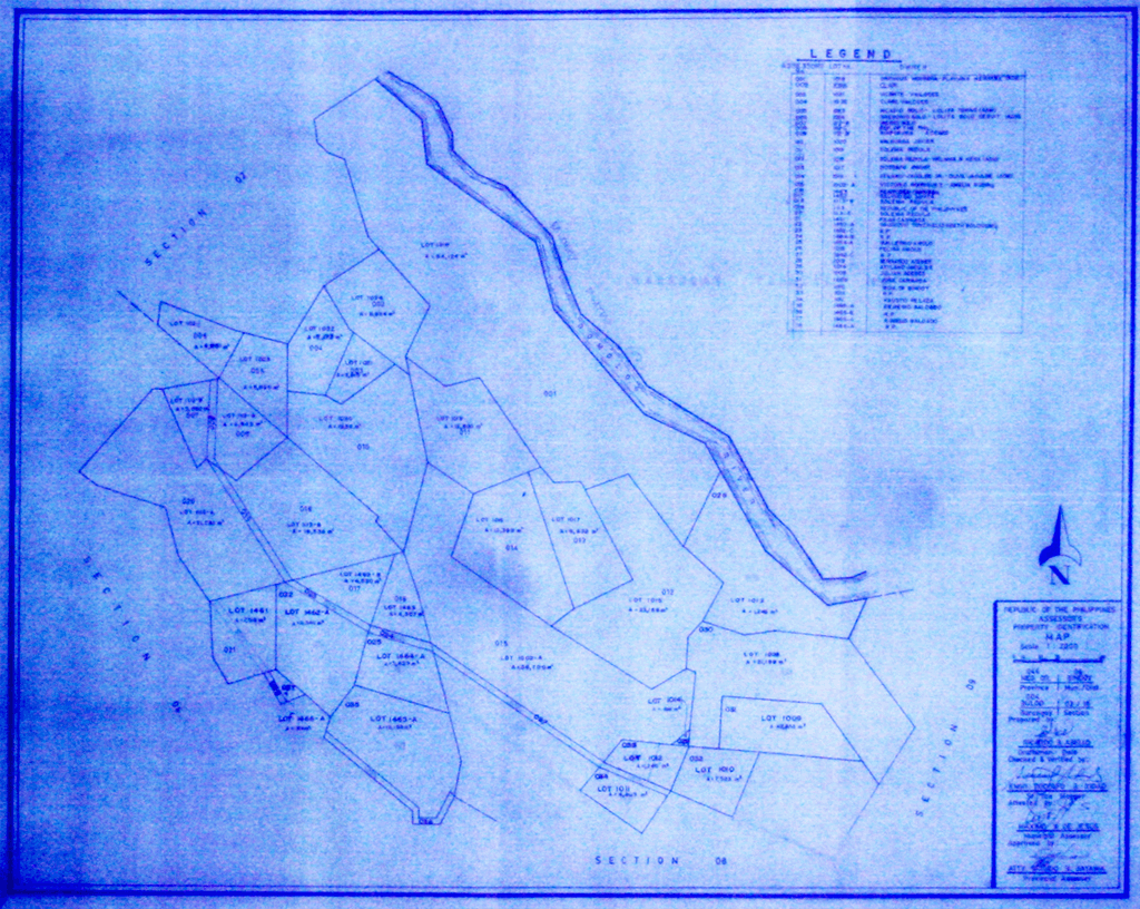
Fig. 7    Cadastral survey data of the official lot data computation (LDC) sheet of the Bureau of Land is encoded into a MS Excel table


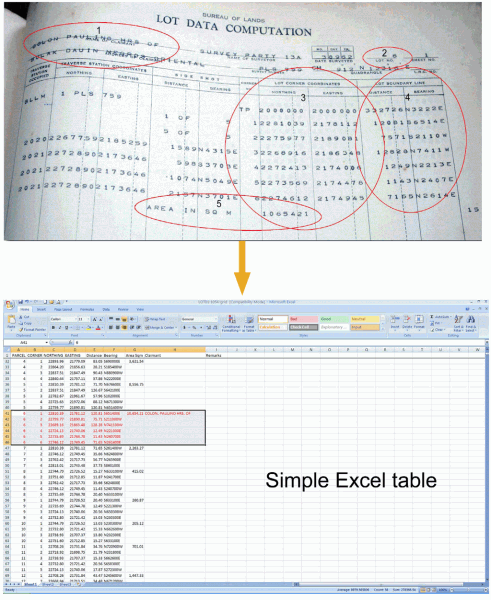
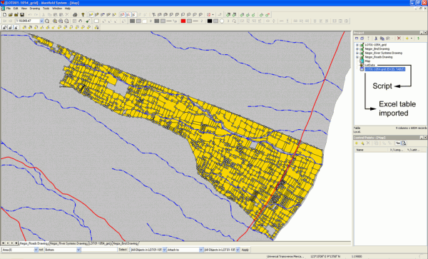
Fig. 8    Using a COGO conversion script all parcel boundaries are generated in a single “run” by the GIS software


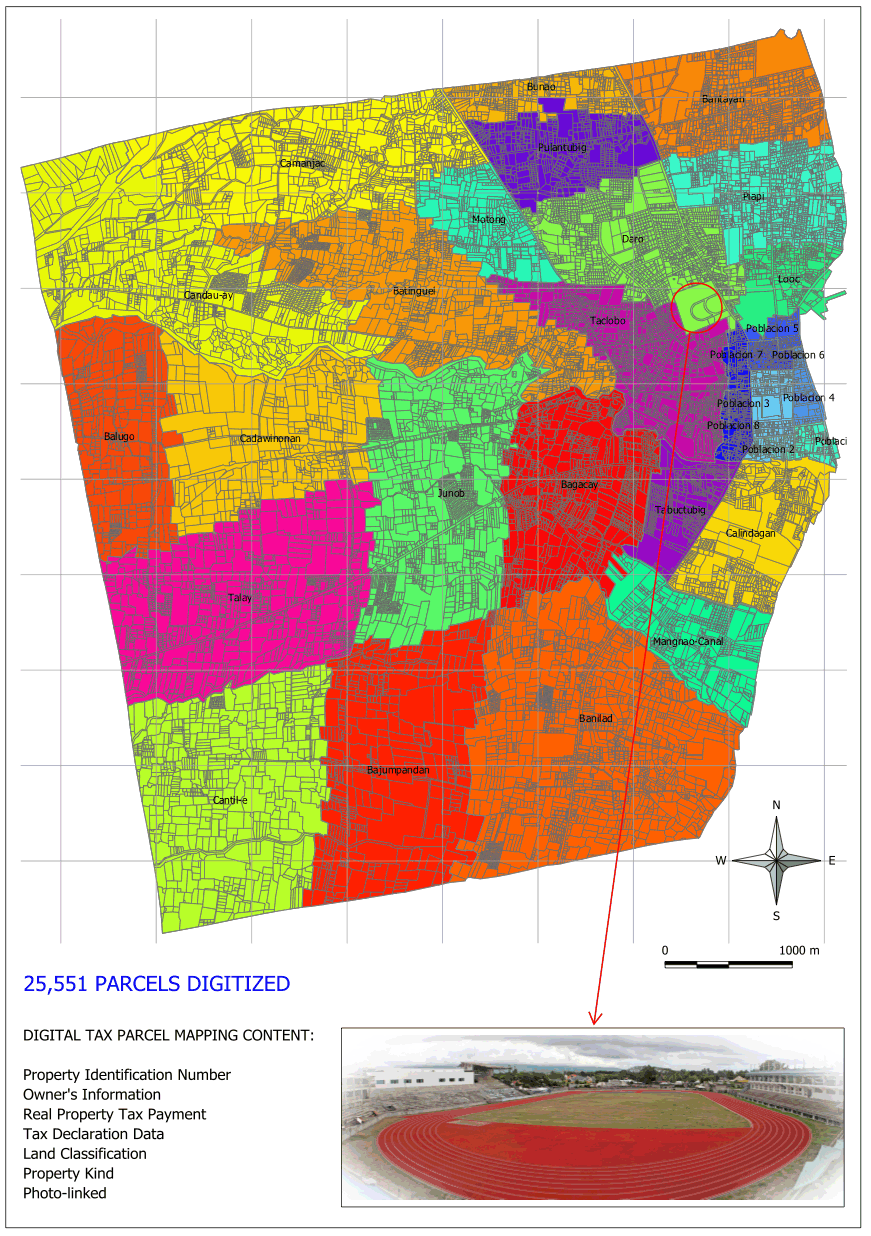
Once the digital parcel map have been generated, the following steps are identical for both approaches mentioned above.


Step 5: Linking the iTAX database with the digital tax parcel map

A noteworthy novelty of the iTAX software is the direct integration of GIS maps into the application. In contrast many other similar attempts to establish a digital parcel mapping system have not proven sustainable because of the fact that the tax database is located in one system while the spatial database to produce the digital tax parcel maps is hosted in a separate GIS application. Experience has shown that tax officers are not inclined to handle two separate applications, particularly when one is also a demanding and complicated GIS software.
The iTAX database and the GIS generated maps share the common field, which is the PIN NO.

The iTAX database contains all tax related data, including:

  • Name and residence of the property owner,
  • Tax declaration assessment,
  • Real property tax registry,
  • Kind of property,
  • Type of ownership,
  • Actual use of land,
  • Payment status, etc.


The implementation of GIS functions into the iTAX application is done by using the Developer Kernel (ActiveX version) of TatukGIS. This is done by object linking and embedding into the PowerBuilder development programme, which in turn is used for creating the iTAX application. Important to note is that the PowerBuilder (Sybase) software can read the map objects of GIS through TatukGIS (ActiveX).
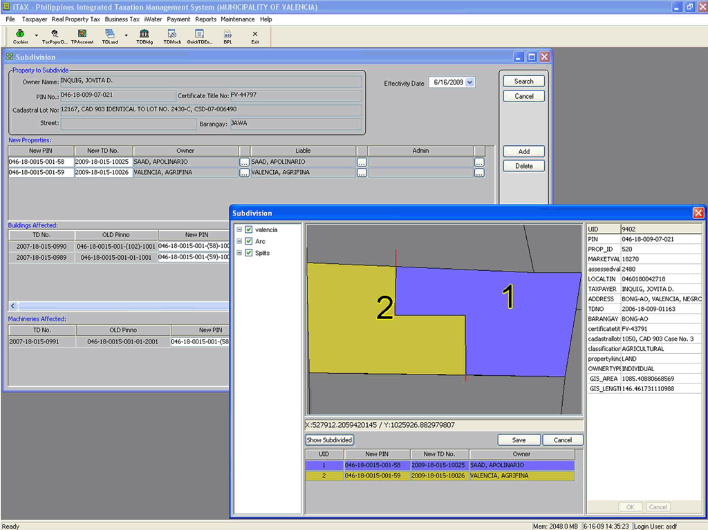
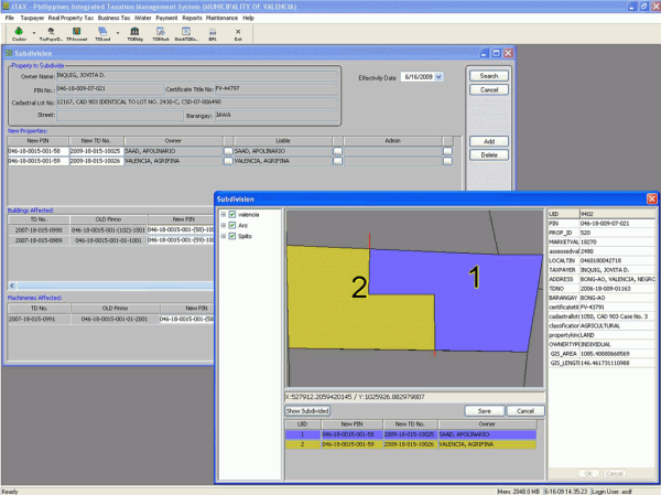
The digital maps (shape files or drawing files) created from the GIS can be integrated through the iTAX application for parcel’s subdivisions and consolidation with the updated Municipal RPT data This is possible as there is a direct link within the computer system that enables the consolidation to be possible. Once the parcel is subdivided or consolidated, automatically a new Property Identification Number (PIN) and a new Tax Declaration Number (TD_No) is assigned. The objective of this application is to ensure that have only one system is necessary for the assessors to update and enter  newly approved parcels, subdivisions or when these need to be consolidated. The application is in the process of being further developed and modified so that it will automatically generate tax related thematic maps and sketch plans of each parcels.


Fig. 9: Sample parcel subdivision inside the iTAX system with its newly assigned PIN and TD_No.


Step 6: Creating/Lay-outing Thematic Maps

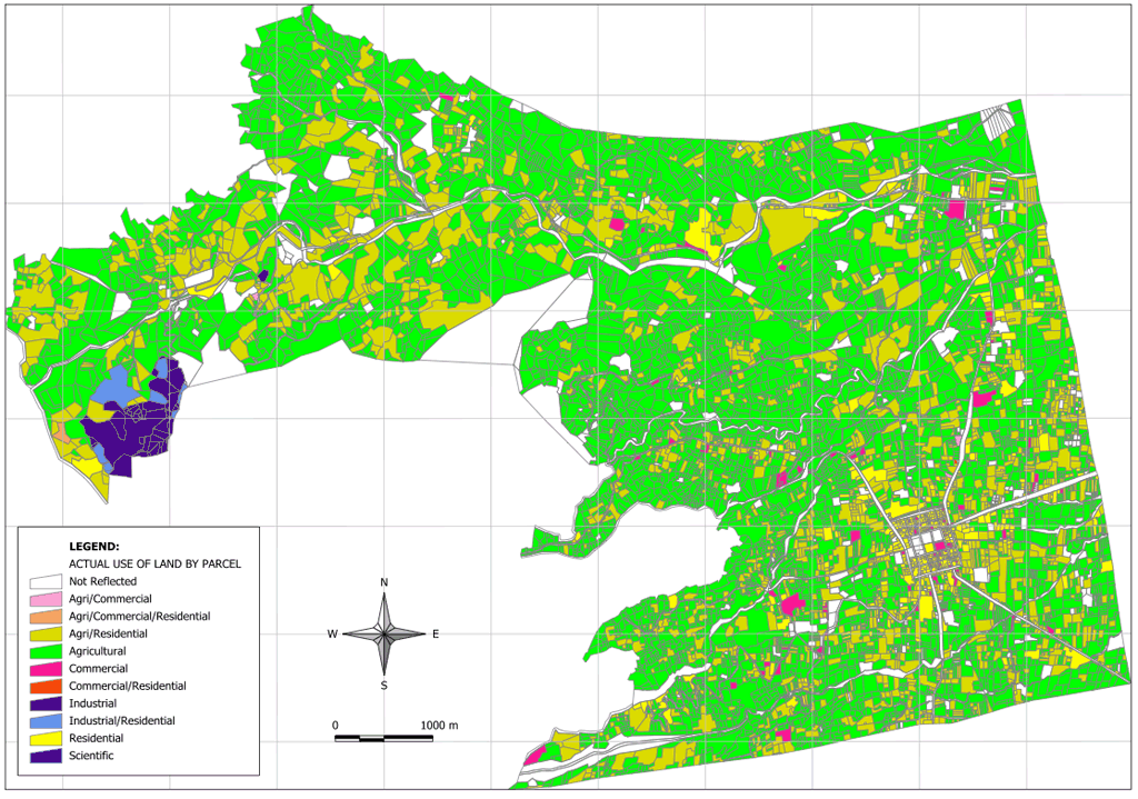
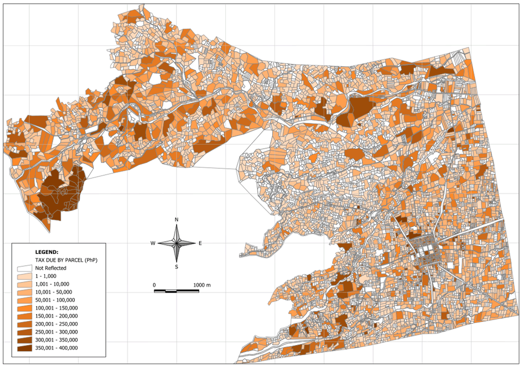
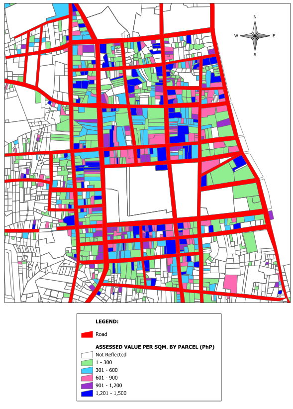
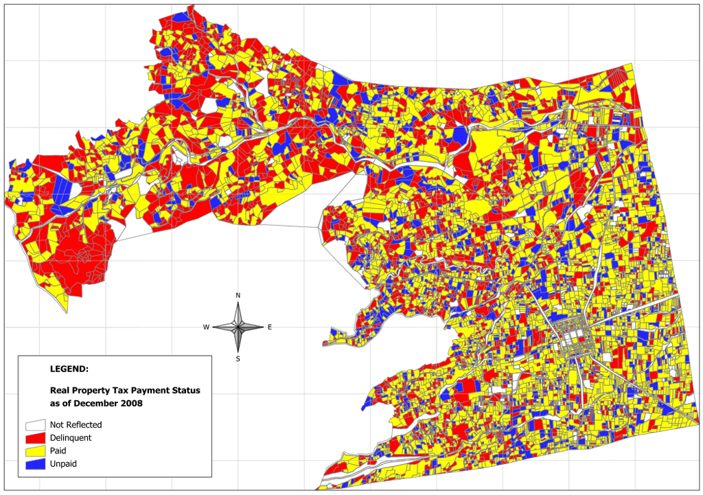
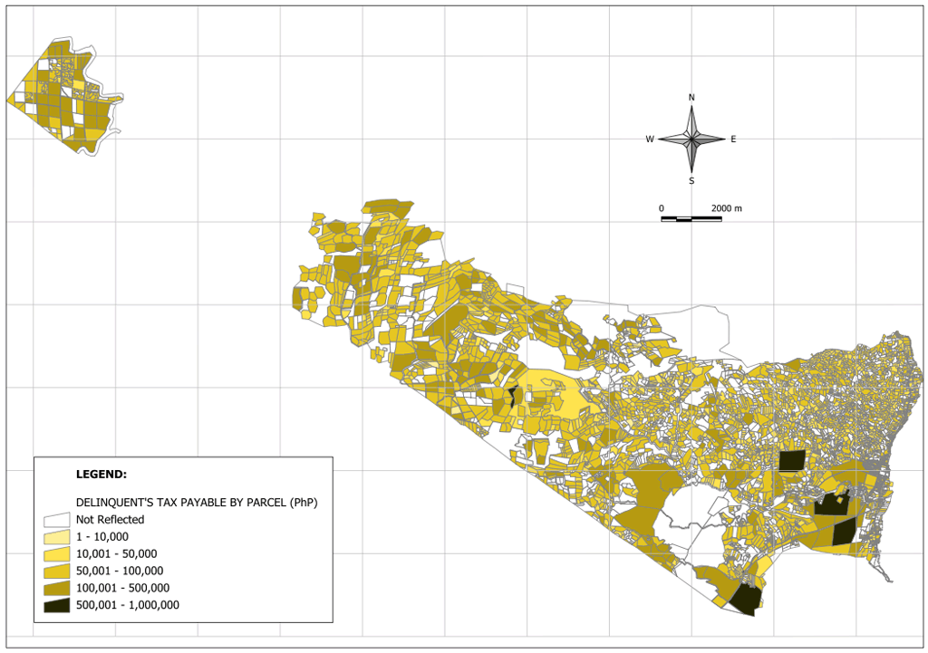
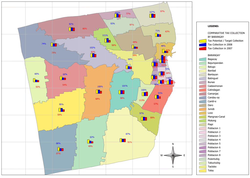
A major advantage of digital tax parcel mapping is the generation of both standardized as well as custom made thematic maps. Examples are theme maps showing land use, payment status, type of ownership, assessed values, market values, type of property improvements etc. depending on the variables stored in the data base.

These maps are integrated into the iTAX application which ensures that the maps always reflect the currently valid tax data.

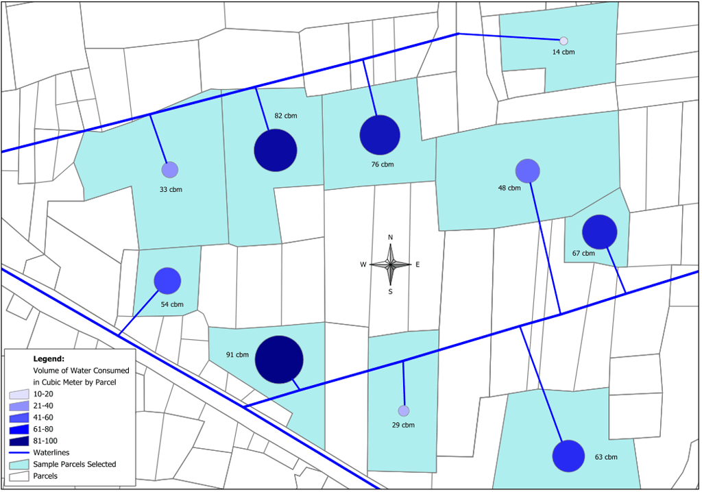
An important application during the build up phase of the digital tax database is the identification of non-plausible values and the checking of the digital database on encoding errors or faulty records of the assessor. Colour coded maps highlight extreme and possibly faulty data records much easier than checking long tabular registers.


files/images_static/result.jpg

Map 1: Type of Land Use by Parcel

Map 2: Digital Tax Parcel Map of a City indicating tax parcels by Barangay

Map 3: Type of Property

Map 4: Type of Ownership

Map 5: Due Tax by Tax Parcel

Map 6: Assessed Value per Square Meter (enlarged section only)
 

Map 7: Real Property Tax Payment Status

Map 8: Deliquent Tax Amount by Parcel

Map 9: Number of Years with Non-Paid Taxes by Parcel

Map 10: Comparative Tax Collection by Barangay

Map 11: Additional revenue collection modules such as water fees can be added to the iTAX database and map on a property parcel basis

Map 12: Digital Tax Parcel Map with its database overlaid on a Google Earth’s Satellite Image